Fluvial Geomorphology in Action!
Dewi Roberts, March 2025
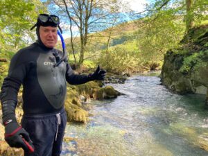
I am very grateful to the BSG for this geomorphological outreach grant which allowed me to develop several videos on the theme of Fluvial Geomorphology in Action. I am also very grateful to the Department of Geography and Earth Sciences at Aberystwyth University for their willingness to let me use their laboratory for the indoor aspect of the project as well as spending time in demonstrating the equipment. My thanks in particular go to Professor Stephen Tooth and also to Dr Ian Saunders for his technical assistance. On the whole, things went according to plan, and I was happy with how the project developed. In response to feedback on the application, I reduced the number of planned videos from 40 to 24 to make it more manageable; in terms of content, I targeted GCSE aged students and used the WJEC Geography specifications for specific information. Another development as a result of feedback was to utilise the 10 Reasons Why Geomorphology is Important booklet; the vast majority of the reasons are well covered in this project (the exception being the global aspect).
The videos are in three main parts based on where they were filmed:
- Laboratory simulations in a stream tray (Emriver) and hydraulic flume
- Examples of fluvial processes, landforms and human impact filmed on local rivers (e.g. the Afon Ystwyth)
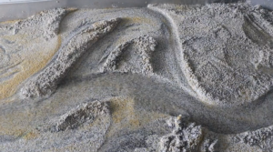
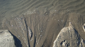
- Examples of small scale fluvial processes and landforms that replicate large scale, including drainage basins on a local beach (Ynyslas)
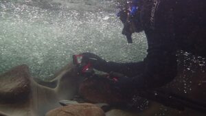
Each video stands alone but may also be used in conjunction with others (I have noted the ones with clear links in the background information for each video where relevant); for example, there is a simulation using the stream tray of the use of riprap on a river bank and also another video showing a real example of this in the field. For each video there is accompanying information which varies in detail depending on content. Videos range in length from 49 seconds to 5 minutes 51 seconds; they are designed to be short and snappy and to grab attention. Movement of sediment is shown in each short film and a number of clips are shot underwater. I tried to get a range of different videos that would be not only educational but also visually appealing, thought-provoking and inspiring.
As a form of summary, listed below are some of the advantages and disadvantages of using the 3 different methods above.
| Location and method | Advantages | Disadvantages |
| Stream tray and flume – simulations | Possibility of setting up numerous scenarios and the ability to re-do/re-run as necessary.
Very useful to adjust flow (of stream tray) and gradient/flow of flume. Worked very well for certain aspects – e.g. delta formation, impact of riprap, meander cut-offs. |
All minor –
Reflections in the flume wall was a problem at times. There was also an issue with reflection off the water in the stream tray even when using a polarizing filter (it was better with lights off). The material in the stream tray wasn’t cohesive enough for some of the planned scenarios e.g. waterfall development. |
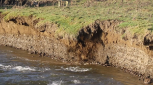
| Filming on and in local rivers | Numerous different processes and landforms can be observed.
There is an option to film underwater. The importance of showing different conditions e.g. river in flood can be emphasised Filming of actual rivers is important in order to see ‘real’ examples of landforms and processes. It is easier to demonstrate that rivers are dynamic, important, and stunning landforms. |
All minor –
– Filming certain aspects was only possible in certain conditions and in specific, known locations. |
| Filming on a local beach | Very good for some processes and landforms e.g. undercutting of banks, drainage network and waterfall development (on mini channels etc in cohesive sand and clay).
Processes happen on miniature landforms in real time and will make it easier, hopefully, for students to understand formations that form in actual rivers over a longer timescale e.g. gorges |
Conditions are suitable only at certain times, normally on an outgoing tide (very wet sand is better, and torrential rain can be of benefit).
The situation changes frequently with shifting sands |
A quick look at public engagement data, six weeks after the videos were uploaded onto YouTube, make very encouraging reading. The most popular to date, the Severn at Caersws, has had over 16,000 views and 126 likes; the second most popular, Erosion has had nearly 7,000 views. There is a clear preference for videos shot in the field but numbers for all videos are increasing, many at a fast pace.
All links in this post go to our YouTube channel: BSG Geomorphology which can also be accessed here. The full Fluvial Geomorphology Outreach playlist can be accessed here. Go and check out all Dewi’s hard work!